Exploring Telford
The Old Canal System
This arm of the canal began in Cherry Tree Hill, at the bottom of Brierley Hill Inclined Plane [large file]. It can be found about fifty yards uphill from the railway bridge, marked as The Old Wynd. It climbs steeply through the woods to Old Wynd House at the top: it would be difficult not to deduce that the Wynd was the winch for the incline! (The archaic spelling is a modern affectation: Tony Clayton's map gives The Old Wind).
The incline was the second attempt at a method of getting boats and material up Brierley Hill. The first was by means of vertical shafts, down which the boats were lowered on end. Charles Boyce, who owns the Old Wynd, drew my attention to the now defunct Old Wynd Tunnel page (now defunct), which documented the exploration by the Shropshire Caving and Mining Club, of a well which in all probability was originally part of that system.
Strictly speaking, the canal began at the top of the incline, since this incline only carried the crates from the boats, not the boats themselves. From there, it ran obliquely across the modern path to the house, being visible on the other side of the track as you approach Crackshall Lane and Queensway. There is a stile at Crackshall Lane, apparently pointless since Queensway was built across the public footpath it used to serve: but if you climb over it you are rewarded with the discovery that there is a bridge remaining under Crackshall Lane, although long since bricked up.
The footpath now begins the other side of Queensway and follows the line of the canal, which ran through the wood: the dry bed of it is still there.
The next section is deduced from few remaining traces - but some of them are unmistakable. It is not surprising that this section of the canal should be hard to trace, since only eight years after it was built a plateway was constructed along the towpath to Horsehay, and the canal for that stretch largely abandoned. (So says Richard Morriss.) However, about the canal:
At the end of the wood the canal is ploughed out. I think it turned to the east (the point is disputed), passing just north of where three lanes, all called Burroughs Bank, converge. At this point there are remains of its course for a few yards both side of the road - heavily overgrown and full of prickly discouragements to exploration. Then it went across the fields to Holywell Lane (where it may have passed by the one house there is) and Woodlands Lane.
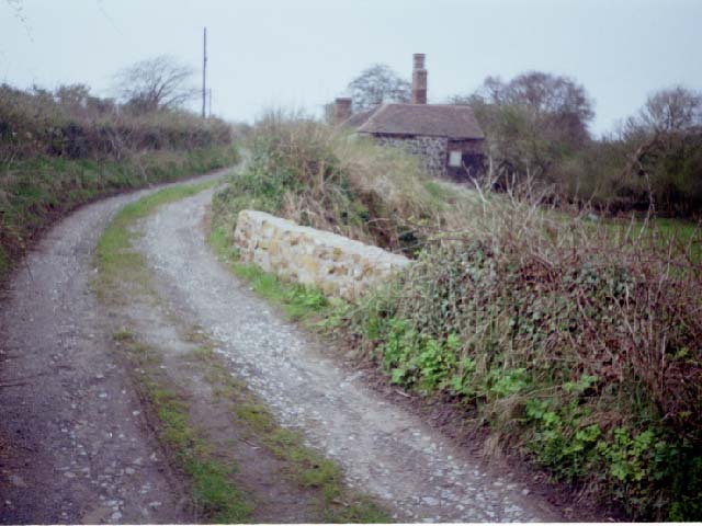
In Woodlands Lane, just below a ruined cottage, the brickwork of a bridge can be found. When I explored this section it was buried in the hedge, only visible if you were looking for it. But sometime since, someone has cleared the vegetation away. Regrettably, they have also seen fit to fill in the bridge arch. This photo shows it as it was from the north, this as it is now from the lane, and this the blocked arch. Behind the cottage, the dry bed of the canal provides a route north; there is a courtesy path now, opened since I first explored there. (I found that section by deduction from the other end, where a path, not on the map, runs along the perimeter fence of Ennstone, formerly Johnson's Pipes.)
In order to cross the stream (originating in Spring Village and flowing down through Doseley and Lightmoor) the canal looped north round the perimeter of the premises of Ennstone, then along the backs of (later?) houses in St Lukes Road, Doseley (See Stories). To the south, it emerged at the point where a railway level crossing used to be: the rails remain, embedded in the tarmac of the road.
I am indebted to Andrew Jones for correcting my account of the next section (Feb 2002). I wrote that "Now we are back with certainties: for a couple of hundred yards between the parallel Holly Road and Gravel Leasoes, the railway track can be walked. It was built on the towpath, and the canal can be discerned in the undergrowth on the Holly Road side".
However, Andrew informed me that The ditch you refer to is not the remains of a canal bed but rather a clever trick of the eye. Some 15 years or so ago the local council rebuilt the road surface of Holly road after knocking down a cottage that used to stand approximatly between the road and the point where you were standing to take the photograph. The 'ditch' used to be the house garden and was a great deal flatter than can be seen today. Also the rails left in the road shows just how much wider Holly road is today than it was 15 years ago prior to the realignment. Interestingly the rails do not line up properly with the tackbed as they were lifted out by myself and other members of Telford Steam Railway to replace the rail keys before the panel was replaced by the contracters slightly in the wrong place.
I think the canal bed was obliterated well before the arrival of the railway as the route of the canal was converted to a jinty rail as told by the Late Bernard Duckett (you can see the small embankment through the trees approaching the scrap yard car park)
Its a shame that the Late Bernard Duckett is not alive anymore, a well known local historian and mine of information regarding the history of Dawley and the surrounding area.
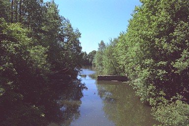
Where Holly Road and Gravel Leasoes turn away from each other both railway and canal carry on, diverging as they approach Little Dawley. There is a good path through the woods to Lightmoor Road, starting from the other side of the canal (the path this side continues, but follows the railway) emerging in the car park of a (former) vehicle dismantler's premises. Crossing Lightmoor Road, under the brick arch of a restored bridge which carried a plateway, the canal can be seen on the left of the path. At first it is dry, but eventually it is in water and broadens out to become Wide Waters Pool. Now a recreational managed pool for fishing, it began life (I am told) as a turning point for canal boats. Surely it has been enlarged since then? Those tub-boats were only 16 feet long.
Castle Pools, further up the path, are also remains of the canal, considerably enlarged by subsidence. At the north end of the second pool, all traces are lost in the development known as Aqueduct (though we are some half-mile from the original Aqueduct village and the aqueduct which gave it its name).
Kevin Lowe sent me additional information about this area:
Castle Pool always used to refer just to the pool at the bottom of Rednal Fields (Little Dawley, now built all over! [Fellowes Close? - RF]) It wasn't until the late 70s, early 80s that all three pools were joined together. There was no link at that time. I remember watching as this was made. As far as I am aware Castle Pool itself was never actually part of the canal system. You are correct that the 'Wide Waters' is larger than perhaps necessary for just a turning point. However, that was not its sole function. We always referred to it as the Reservoir and that is how (I have since found) it is referred to on old maps. So basically it was this size to hold a store of water for the system.
I remember many years ago mapping out the ruins of Dawley Castle. Only the foundations were left and my father and I spent a day with an iron bar and tape determining the layout of the walls. Later this area was covered in mounds of earth during the 'landscaping' of the area. The nature of the area has changed completely since I was a child. I revisited a couple of years ago and was surprised to see all the trees. It was all quite open all those years ago. To be honest I don't like it at all now. There are too many people and the place has turned into a park.
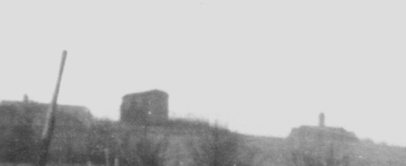
I was sad to find that Rednal Fields had been built on and that the Victorian Pumphouse about half way up had been demolished. I used to know the engineer that operated it and often went in to look at the machinery and all the wrought ironwork. I thought you might be interested in the attached photo
. I It shows the top of Rednal Fields in Little Dawley. I'm not sure of the date and my relatives who might have known are long dead. The box-like structure, left of centre is the pumphouse. The scale is difficult to determine from the photo but from memory I would say it was at least as high as a 3 storey house. At bottom right of the building there was a large arched gateway with greeny-blue doors topped by an arched window. Above this was a square window in the room above the entrance. The rest of the front of the building comprised two very large windows floor to roof, This was the machine room and was partly obscured by ivy. Round the top was a white band of bricks. I've always liked Victorian architecture and this was a lovely little building. I'm not absolutely sure where it pumped water from and to. The engineer used to take me in and show me the machinery. He also used to give me tea laced with a generous amount of whiskey! I'm not sure what the structure to the right is. Perhaps some sort of mine? Possibly what the pump house was created for? At high magnification it appears to have a slope leading down to mounds of material at right. I remember that something was there but can't recall the details. I know the area was dotted with little shafts: as children we were always looking into them, before they were capped off. We were always warned to stay away from them.
The engineer had a house to the left of the pumphouse.
Although impossible to make out in the picture, the thick dark band at the base of the pump house was a wrought iron railing interwoven with brambles. This is where we kids used to pick blackberries and catch grasshoppers and butterflies (not acceptable today!) on hot summer days.
Tony Clayton's map shows the canal crossing Southall Road just south of its name-change to Castlefields Way. It entered the wood opposite, turning south, and after a couple of hundred yards its line has been taken over by a path which curves round between Mallory Drive and Chapel Lane.
There is a high bridge over a tarmac path in a deep cutting. That path is the earliest of three visible alignments of Southall Road - the coach road before it was diverted to cross the railway - and the bridge is the aqueduct at Aqueduct. Thereby hangs a tale.
The canal, now running north-east, crossed the later line of Southall Road next to the disused railway bridge, and connected with the Coalport and Hollinswood arms in the air about a dozen feet above the Silkin Way footpath, a former railway which followed the line of the canal. And that's another tale.