Exploring Telford
The Old Canal System
This section begins at the junction of the main arm from Coalport, and the branch to Coalbrookdale, just to the north of the Southall Road bridge over the Silkin Way - a path built along the line of the railway which succeeded the canal; but the water level was at the level of the top of the embankment to the west. It passed through a tunnel, indicated by the terrace of houses to the right (which you can't see from the path), which is called Tunnel Cottages. Intriguingly, on the David & Charles map it is shown as Tunnel House - it doesn't look as though it was ever a single dwelling. Tony Clayton's map calls it Tunnel Row.
The tunnel may have ended at about the point where the path, which has been climbing slowly, levels off - but the water level is still at the level of the top of the cutting, not at foot level, and remains so to the next bridge - that under Stirchley Lane.
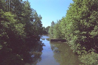
Once under the Stirchley Lane bridge you could be forgiven for detecting the canal below you and to your right. Or at least, I'll forgive you, because that is what I did. Actually, it runs somewhat further along the path, still at a higher level, before veering off to the left. There are several small paths, of which the third runs between the canal bed and the railway/path, and the canal can be clearly seen. Eventually, opposite a wide path, almost a road, to the right, there is a clear, maintained path left. Fifty yards up that path you will see the bed of the canal to your left, whilst to the right, it is in water, with lilies, ducks and fishermen (when in season). Here also are Hinkshay Pools, the upper a canal reservoir, the lower the result of a breach in the upper.
(April 2006) Mr Neil Partridge emailed me about this section: Since living in Malinslee (21 years) I have been fishing at Stirchley Pools very often and have heard different information about the lower pool. It is said that the deeper side (nearest the canal) is at least 18 ft in parts and was in fact a turning point for the canal transport. It is also said that there is a sunken brick wall that runs part of the length of the pool. I hope this is informative but I don't know if what I have been told is 100% correct.
Beyond the end of the section of canal in water it can be seen, dry, making off through the trees. I do not recommend following it: it is very hard going and extremely muddy. I know - I fell in it. Instead, turn right, then left back onto the railway/path.
The next landmark is where the path divides, the old railway going forwards but the more important modern path branching left and climbing towards Telford Town Centre. If you had followed the canal, you would have emerged from the undergrowth a few yards up that path, dirty and exhausted.
The line then leads under a footbridge, the path over which runs from Stirchley Chimney to Hinkshay. The path runs level along the side of the hill to Hollinswood, where the modern St Quentin Roundabout and its approach roads cut across it. It may well be literally true, here, that the railway was built on the canal bed, although further south it can't be: and, as Tony Clayton's map shows, it continued so through the next section, as far as the Greyhound Inn on Holyhead Road.